A: TEMPERATURES - Temperatures continued to be cooler than average. This past week temperatures were coolest in AB and warmest in MB (Fig. 1). Average temperatures for May 12 to June 11, 2019, were approximately 1°C cooler than average (Fig. 2).
 |
| Figure 1. Average temperature (°C) across the Canadian prairies over the past SEVEN days (June 5-11, 2019). |
 |
| Figure 2. Average temperature (°C) across the Canadian prairies over the past 30 days (May 12-June 11, 2019). |
 |
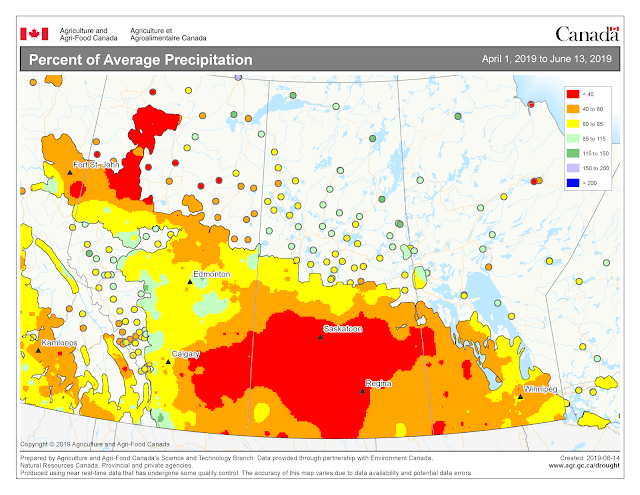
| Figure 3. Percent of Average precipitation across the Canadian prairies for the growing season (April 1-June 13, 2019). Image has not been reproduced in affiliation with, or with the endorsement of the Government of Canada and was retrieved (14Jun2019). Access the full map at http://www.agr.gc.ca/DW-GS/current-actuelles.jspx?lang=eng&jsEnabled=true |
The growing degree day map (GDD) (Base 5 ºC, April 1-June 10, 2019) is below (Fig. 4):
 |
| Figure 4. Growing degree day (Base 5 ºC) across the Canadian prairies for the growing season (April 1-June 10, 2019). Image has not been reproduced in affiliation with, or with the endorsement of the Government of Canada and was retrieved (14Jun2019). Access the full map at http://www.agr.gc.ca/DW-GS/current-actuelles.jspx?lang=eng&jsEnabled=true |
The growing degree day map (GDD) (Base 10 ºC, April 1-June 10, 2019) is below (Fig. 5):
 |
Figure 5. Growing degree day (Base 10 ºC) across the Canadian prairies for the growing season (April 1-June 10, 2019).
Image has not been reproduced in affiliation with, or with the endorsement of the Government of Canada and was retrieved (14Jun2019). Access the full map at http://www.agr.gc.ca/DW-GS/current-actuelles.jspx?lang=eng&jsEnabled=true |
The lowest temperatures (°C) observed the past seven days are reflected in the map below (Fig. 6).
 |
| Figure 6. Lowest temperatures (°C) observed across the Canadian prairies the past seven days (June 7-13, 2019). Image has not been reproduced in affiliation with, or with the endorsement of the Government of Canada and was retrieved (13Jun2019). Access the full map at http://www.agr.gc.ca/DW-GS/current-actuelles.jspx?lang=eng&jsEnabled=true |
 |
| Figure 7. Highest temperatures (°C) observed across the Canadian prairies the past seven days (June 7-13 2019). Image has not been reproduced in affiliation with, or with the endorsement of the Government of Canada and was retrieved (14Jun2019). Access the full map at http://www.agr.gc.ca/DW-GS/current-actuelles.jspx?lang=eng&jsEnabled=true |
B: PRECIPITATION - During the past seven days, rainfall in central regions of AB and southern MB was reported to be greater than 15 mm (Fig. 8). Little or no rain was reported across central areas of SK. Rainfall totals for May 12-June 11 indicated that rainfall amounts were greatest in AB and MB (Fig. 9) while conditions continue to be very dry across most of SK (Fig. 10).
 |
| Figure 8. Cumulative precipitation (mm) across the Canadian prairies over the past SEVEN days (June 5-11, 2019). |
 |
| Figure 9. Cumulative precipitation (mm) across the Canadian prairies over the past 30 days (May 12-June 11, 2019). |
 |
| Figure 10. Modeled soil moisture (%) across the Canadian prairies (up to June 11, 2019). |