Throughout this past week, the average temperature was approximately 1 °C cooler than normal (Fig. 1). Compared to last week, the prairie-wide average daily temperature was 3 °C warmer. The warmest temperatures were observed across the Parkland region of the prairies.
 |
| Figure 1. Average temperature (°C) across the Canadian prairies the past seven days (May 22-28, 2019). |
The average 30-day temperatures were approximately 3 °C cooler than average (Fig. 2).
 |
| Figure 2. Average temperature (°C) across the Canadian prairies the past 30 days (April 28-May 28, 2019). |
Seven-day cumulative rainfall (Fig. 3) indicated that minimal rain was observed across large areas of SK. Most locations reported less than 5 mm. Wetter conditions were reported in a corridor between Lethbridge and Calgary AB. Most of MB and southeast SK had rainfall amounts that were greater than 10 mm (Fig. 3).
 |
| Figure 3. Cumulative precipitation observed the past seven days across the Canadian prairies (May 22-28, 2019). |
 |
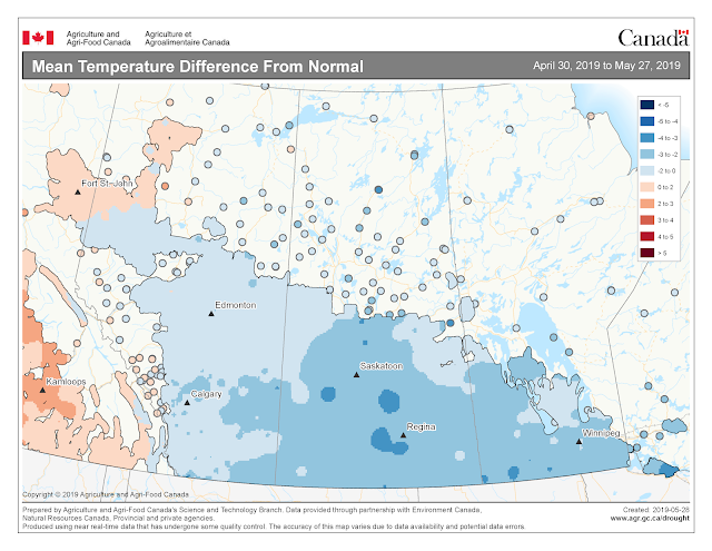
| Figure 4. Mean temperature differences from Normal across the Canadian prairies from April 30-May 27, 2019.Image has not been reproduced in affiliation with, or with the endorsement of the Government of Canada and was retrieved (30May2019). Access the full map at http://www.agr.gc.ca/DW-GS/current-actuelles.jspx?lang=eng&jsEnabled=true |
Across the prairies, rainfall amounts for the past 30 days (April 28-May 28, 2019) have been approximately 50% of normal (Fig. 6). The 30-day rainfall totals have improved in MB and southwest SK.
 |
| Figure 5. Cumulative precipitation observed the past 30 days across the Canadian prairies (April 28-May 28, 2019). |
Growing season rainfall (April 1 – May 28) amounts have been well below average for most of the prairies, particularly in west central SK and eastern regions of AB (Fig. 6).
 |
| Figure 6. Cumulative precipitation observed for the growing season across the Canadian prairies (April 1-May 28, 2019). |
 |
| Figure 6. Percent of Average precipitation across the Canadian prairies for the growing season (April 1-May 28, 2019).Image has not been reproduced in affiliation with, or with the endorsement of the Government of Canada and was retrieved (30May2019). Access the full map at http://www.agr.gc.ca/DW-GS/current-actuelles.jspx?lang=eng&jsEnabled=true |
Soil moisture values are low across most of the prairies.
 |
| Figure 7. Modeled soil moisture (%) across the Canadian prairies (up to May 28, 2019). |
The two week forecast is not predicting significant rainfall for the prairies. The Agroclimate National Risk Report for May 7 to May 22, 2019 reports that there is less than a 30% chance of rainfall amounting to >25 mm (May 29-June 4, 2019). The report states that “No rain is expected in the week ahead in areas currently experiencing drought conditions such as southwestern Saskatchewan”.
 |
| Figure 8. Forecast probability of total precipitation >25 mm for the period of May 29 to June 4, 2019. Image has not been reproduced in affiliation with, or with the endorsement of the Government of Canada and was retrieved (30May2019). Access the full map at http://www.agr.gc.ca/eng/programs-and-services/drought-watch/agroclimate-national-risk-report-may-7-to-may-22-2019/?id=1556301780170 |
The growing degree day map (GDD) (Base 5 ºC, April 1-May 27, 2019) is below (Fig. 9):
 |
| Figure 9. Growing degree day (Base 5 ºC) across the Canadian prairies for the growing season (April 1-May 27, 2019).Image has not been reproduced in affiliation with, or with the endorsement of the Government of Canada and was retrieved (30May2019). Access the full map at http://www.agr.gc.ca/DW-GS/current-actuelles.jspx?lang=eng&jsEnabled=true |
The growing degree day map (GDD) (Base 10 ºC, April 1-May 15, 2019) is below (Fig. 10):
 |
| Figure 10. Growing degree day (Base 10 ºC) across the Canadian prairies for the growing season (April 1-May 27, 2019).Image has not been reproduced in affiliation with, or with the endorsement of the Government of Canada and was retrieved (30May2019). Access the full map at http://www.agr.gc.ca/DW-GS/current-actuelles.jspx?lang=eng&jsEnabled=true |
The lowest temperatures (°C) observed the past seven days range from -6 to 6 °C in the map below (Fig. 11).
 |
| Figure 11. Lowest temperatures (°C) observed across the Canadian prairies the past seven days (May 23-29, 2019). Image has not been reproduced in affiliation with, or with the endorsement of the Government of Canada and was retrieved (30May2019). Access the full map at http://www.agr.gc.ca/DW-GS/current-actuelles.jspx?lang=eng&jsEnabled=true |
 |
| Figure 12. Highest temperatures (°C) observed across the Canadian prairies the past seven days (May 23-29, 2019). Image has not been reproduced in affiliation with, or with the endorsement of the Government of Canada and was retrieved (30May2019). Access the full map at http://www.agr.gc.ca/DW-GS/current-actuelles.jspx?lang=eng&jsEnabled=true |