This past week (July 2 - 9, 2018), temperatures across the prairies were warmer than long term average values (Fig. 1). The warmest weekly temperatures continue to occur across Manitoba. Compared to last week, daily average temperatures were warmer across southern Alberta and Saskatchewan. The 30-day (June 9 - July 9, 2018) average temperature was similar to the long term average.
 |
| Figure 1. Weekly (July 2 - 9, 2018) average temperature (°C). |
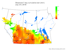
Weekly and 30-day total precipitation was slightly above average (Figs. 2 and 3). Weekly accumulations were generally less than 20 mm with a few areas (northeast Saskatchewan, northwest Manitoba and the south of the Peace River region) reporting greater than 40 mm. The wettest (30-day) regions were across eastern areas in Saskatchewan, and isolated areas in southern Manitoba and the south of the Peace River region. A large region across Saskatchewan and Alberta continues to be dry.
 |
| Figure 2. Weekly (July 2 - 9, 2018) cumulative precipitation (mm). |
 |
| Figure 3. The 30-day (June 9 – July 9, 2018) cumulative precipitation (mm). |
The maps above are all produced by Agriculture and Agri-Food Canada. Growers may wish to bookmark the AAFC Drought Watch Maps for the growing season.

