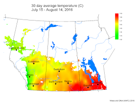
Across central Alberta, Saskatchewan, and Manitoba, average cumulative rainfall was well above LTN values.
The average 30 day temperature for July 8-August 7, 2016, was similar to LTN and rainfall was 50% greater than LTN (average across the prairies). The wettest conditions have been in south and central areas of western Saskatchewan and central Alberta.
The average growing season temperature (April 1- August 7, 2016) was marginally warmer than normal. Growing season rainfall has been approximately 28% above average.
The map below shows the modelled soil moisture across the prairies (August 14, 2016).
The updated growing degree day map (GDD) (Base 5ºC, March 1 – August 14, 2016) is below:
While the growing degree day map (GDD) (Base 10ºC, March 1 – August 14, 2016) is below:
The map below shows the Lowest Temperatures the Past 7 Days (August 10 - August 16, 2016) across the prairies:
The map below shows the Highest Temperatures the Past 7 Days (August 10 - August 16, 2016):
The maps above are all produced by Agriculture and Agri-Food Canada. Growers may wish to bookmark the AAFC Drought Watch Maps for the growing season.
Additional precipitation and temperature data or maps are provided by the following:
Manitoba Agriculture's Crop Weather Report
Alberta Agriculture and Food's Weather Stations
Saskatchewan's Cumulative Precipitation Map
Environment Canada's Historical Data Interface


