Across the southern prairies, the 7-day average cumulative rainfall was well above LTN values.
The average 30 day temperature for June 17 to July 17, 2016, was similar LTN and rainfall was 20% greater than LTN.
The average growing season temperature (April 1 – July 17, 2016) has been less than 1°C warmer than normal.
Growing season rainfall has been approximately 20% above average.
The map below is the modelled soil moisture map for the prairies (up to July 17, 2016).
The map below shows the Lowest Temperatures the Past 7 Days (July 13-19, 2016) across the prairies:
The map below shows the Lowest Temperatures the Past 7 Days (July 13-19, 2016) across the prairies:
The map below shows the Highest Temperatures the Past 7 Days (July 13-19, 2016):
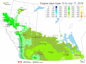
The updated growing degree day map (GDD) (Base 5ºC, March 1 – July 17, 2016) is below:
While the growing degree day map (GDD) (Base 10ºC, March 1 – July 17, 2015) is below:
The maps above are all produced by Agriculture and Agri-Food Canada. Growers may wish to bookmark the AAFC Drought Watch Maps for the growing season.
Additional precipitation and temperature data or maps are provided by the following:
Manitoba AGriculture's Crop Weather Report
Alberta Agriculture and Food's Weather Stations
Environment Canada's Historical Data Interface


